Assam Floods
Assam is hit by devastating floods almost every year. While rainfall patterns and the topography of the region contribute largely to the recurring floods, increased human intervention over the years has made it even worse. This includes unplanned urbanization, deforestation, the encroachment of river banks, etc.
The Brahmaputra River surrounds a large part of Assam, except for a few places. It is unstable due to steep slopes and high sedimentation. Assam falls in an earthquake-prone zone and heavy and prolonged rainfall every year.
According to the Assam State Disaster Management Authority (ASDMA), 2017 has been the worst in the last four years of floods. Assam floods in 2014 impacted over 1800 villages, displacing nearly 1.6 million people. In 2015, approximately 1.5 million people were displaced and over 1,000 villages affected. 2016 saw a drastic jump from 2015 with over 2500 villages affected and about 1.7 million being displaced.[10]
Effects of Assam floods
Assam experiences destructive floods every year. While in some cases, people find their way back to recovering from their physical loss, their emotional and mental trauma may be irreparable.
The flood situation in Assam has gone from bad to worse in the last few years. As of 2019, nearly 40% of the total land in the state has become severely flood prone due to yearly wear and tear of the region. Below given is the estimated damage caused by Assam floods from 1953 to 2016:
From 1953 to 2016, the estimated number of people affected annually, on average, totals up to 26 lakh, with the maximum damage being done in 2004 affecting 1.2 crore lives. The value of damage to home, on an average, is estimated at 7 crores annually, with the maximum damage done in 1988 at 103 crores. The loss of cattle, on average, estimates to about 10, 961 annually, with the maximum loss recorded in 2004 at 1, 18,772. The loss of lives due to Assam floods, on an average, approximately totals up to 47 annually, marking the highest record in 2004 with 497 deaths. The total damage including crops, houses and public utilities in the state, on average, adds up to 128 crores annually, with the maximum damage done in 2012 at 3200 crores.[11]
The state of Assam has experienced 12 catastrophic floods since 1950. While changes in the pattern of floods have been noticeable through the last one decade, prominent shifts in the frequency of floods have only occurred in the last few years. Assam floods have costed the lives of over 120 people in 2012, 42 in 2015, 28 in 2016, 85 in 2017 and 12 in 2018.[12]
Measures taken to control floods in Assam
In 1982, the Brahmaputra Board in its master plan suggested to build reservoirs and dams in order to mitigate floods. It proposed a multipurpose dam in Gerukamukh in Dhemaji, Assam, but the proposal was rejected due to objections from the Arunachal Pradesh Government; their concerns related to submergence of small towns.
The government has been using the single pronged approach of building embankments on the river to prevent floods. While these embankments were proposed years back as an interim or a short term measure only, they have stayed on for much longer than that. Moreover, these embankments are weak and regularly breached due to low investment in its building. Some of them were even built in the 1980s and have not been maintained since then. [13]
Possible long-term solutions to prevent floods in Assam
The problem of recurring floods in the state of Assam has not been addressed seriously by the central government. While floods cannot be completely avoided, certain preventive measures can be taken to reduce the damage. These include:
- Reconstruction of embankments
- Increasing forest cover
- Clearing drainage system in urban areas
- Wetlands rejuvenation
- Building more reservoirs to hold excessive water during the monsoon
- Planning and putting into action holistic rainwater harvesting plans
- Decentralized weather forecast
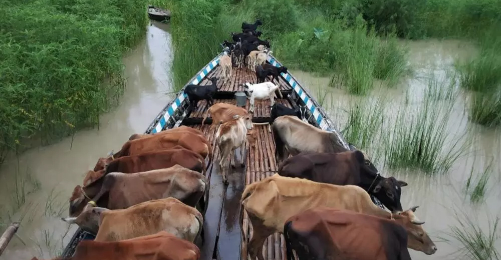
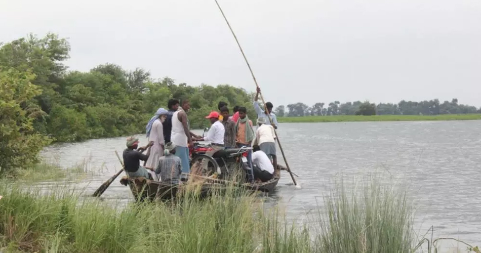
Assam Floods 2019
Continuous heavy rainfall has wreaked havoc in the state of Assam. More than 70 lakh lives have been affected and 90 dead in Assam due to the 2019 floods. Impacting over 4600 villages in more than 30 districts including Dhubri, South Salmara, Morigaon, Barpeta, Dhemaji and Lakhimpur, floods in Assam have caused irreparable damage in people’s lives. Nearly 2 lakh hectares of agricultural land, livestock and fish ponds have been destroyed, resulting in loss of livelihood. The Kaziranga National Park had submerged with about 10 lakh animals facing flood fury.
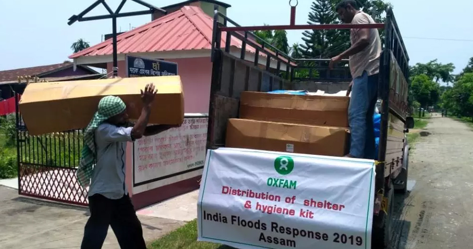
Oxfam India’s Response
Oxfam India along with its local partners has been tirelessly working in Lakhimpur, Dhemaji, Barpeta, Moregaon, Dhubri and South Salmara, providing flood relief support to affected people. We have provided emergency shelter and hygiene kits to 15,420 people, trained nearly 30,000 people on hygiene practices and installed 30 temporary toilets benefiting around 3,600 people. Additionally, 12 water filters were installed giving 2,664 men, women, and children access to safe drinking water. Nearly 20 hand pumps have been cleaned, 18 more installed, and 20 bathing cubicles have been constructed.
Click here to read more: https://www.oxfamindia.org/programdetails/1/humanitarian-response-and-drr
We need your support!
Support Oxfam India to help us reach out to more and more people in times of crises. Donate to Assam Relief Fund and help Oxfam India sustain its efforts of rehabilitating flood-affected people.
Click here to read more on Oxfam India’s work in Assam: https://www.oxfamindia.org/blog/oxfam-india-stands-flood-affected-families
Bihar Floods
76 per cent of the population in Bihar lives under a constant threat of flood destruction. Over 60,000 sq. km area in Bihar is highly prone to floods. Adjoined by Nepal, the Bihar plains are drained by several rivers including Kosi, Burhi Gandak, Bagmati, Balan, Kalma, Adhwara and Mahananda. Rivers originating from Nepal carry high discharge and sediment load which is dropped in the plains of Bihar.
Northern Bihar has recorded the maximum number of floods over the last 30 years. In 1978, 1987, 1998, 2004, and 2007, the state experienced some of the most devastating floods in the history of India.[14]
Bihar accounts for nearly half of India’s average flood loss in the country. While the state experiences destructive floods every year, the frequency and magnitude of these floods has gone from bad to worse over the last few years, facing extensive damage to life and property. Bihar witnessed the worst floods in 2008 affecting more than 30 lakh people in more than 1500 villages spread across 16 districts. The worst affected districts in the 2008 Bihar Floods included Saharsa, Supaul, Araria, and Madhepura.
Floods in Bihar are contributed largely by River Kosi, a major tributary of the Ganges. The Kosi River system drains large areas of the Eastern Nepal and Southern Tibet before entering Bihar. This river basin covers approximately half of the world’s significant peaks including India-Nepal Border, also known as the Sapt Kosi or Seven Rivers; the tributaries of the Sapt Kosi include Indrawati, Sunkosi, Lihku Khola, Tambakosi, Dudhkosi, Arun, and Tamur.[15]
What causes floods in Bihar?
Forests are being rapidly converted to agricultural land in Nepal over the past many years, contributing greatly to the increasing floods in India. From the 1950s to the 1980s, there was an annual increase in the run off in the Sapt Kosi and also in the rainfall in some stations of the basin. While the state government has built an embankments cover of nearly 3,000 km in Bihar, it not sufficient given that the river flow has multiplied by 2.5 times, resulting in the failure of these embankments during floods.
Possible long-term solutions to prevent floods in Bihar
While there is no permanent solution to stopping flood occurrence, some preventive measures can help in minimising flood damage. These include:
- Embankments: gaps in the existing embankments in Bihar reduce the effectiveness of these provisions. These should be repaired and maintained at regular intervals to ensure smooth and proper functioning.
- Detention basins: detention basins can absorb large amounts of water during floods. These should be repaired and upgraded as and when required.
Click here to read more on Bihar floods: https://www.oxfamindia.org/blog/making-communities-resilient-flood-prone-bihar
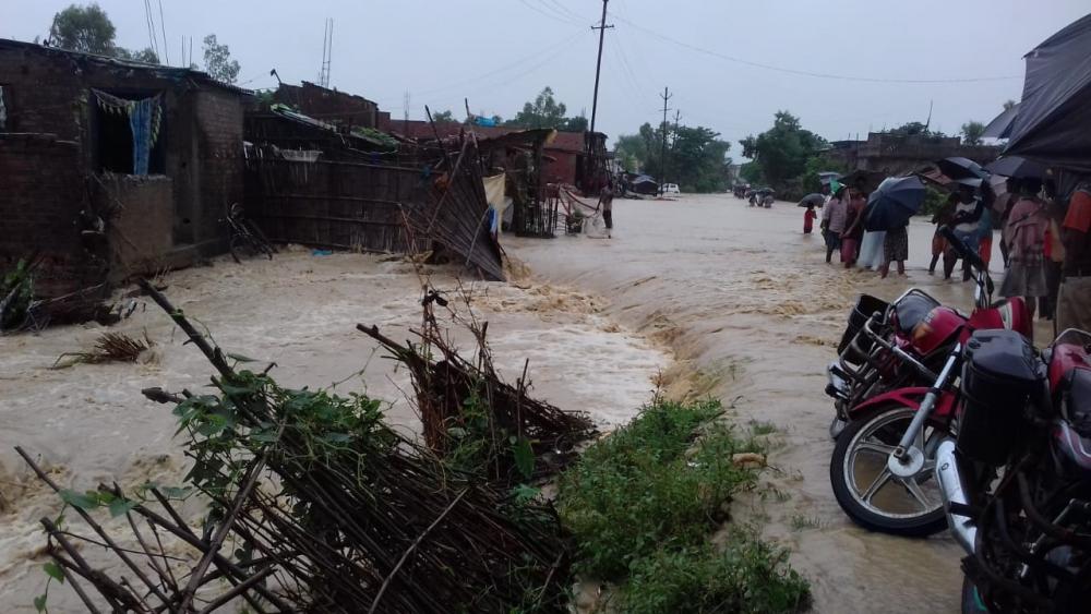
Bihar Floods 2019
The 2019 Bihar Floods have impacted more than 80 lakh and killed approximately 130 people. Incessant rainfall resulted in floods in 13 districts of Bihar and displaced about 1 lakh people. The worst affected districts in Bihar include Sitamarhi, Sheohar, Madhubani, Araria, East Champaran, Kishanganj, Supaul, Darbhanga, Muzaffarpur, Saharsha, Katihar, and Purnia. According to the India Meteorological Department (IMD), North Bihar received record-high rainfall from 12-13 July 2019.
Oxfam India’s Response
Oxfam India did a needs assessment study in Bihar to identify long-term needs of flood victims. We chlorinated 487 hand pumps in the Sitamarhi district of Bihar, benefitting over 11,000 people. Nearly 5,000 people have been sensitised on child trafficking so far since possibilities of such episodes increase in times of crises.
Click here to read more: https://www.oxfamindia.org/floods-in-india
We need your support!
Support Oxfam India to help us reach out to more and more people in times of crises. Donate to Assam Relief Fund and help Oxfam India sustain its efforts of rehabilitating flood-affected people.
Kerala Floods
The state of Kerala does not experience floods as worse as the Indo-Gangetic Plains do but it is becoming more prone to flooding by the year. While Kerala floods largely occur as a result of incessant heavy rainfall, other factors that contribute to Kerala floods include mismanagement of water resources and forests. Human interventions including reclamation of wetlands and water bodies, construction and expansion of roadways, establishment of more and more settlements, deforestation, etc. have increased over the last few years in Kerala. It is estimated that 26% of the total geographical area of Kerala is prone to floods.[16]
What causes Kerala floods?
A report following the 2018 Kerala Floods suggested that neither the dams in the state have effective flood cushions, nor did they have proper flood control zone. Had the two been in place, the effects of floods could’ve been contained to a great extent.
Dams in Kerala lack Emergency Action Plan (EAPs), despite National Disaster Management Authority’s mandate to have it by 2009. The EAP is a written document which contains plans to prevent or lessen the effect of a failure of a dam. Most reservoirs usually get filled up even before extremely heavy rainfall hits the state. They lack the capacity to accommodate additional flow of water. This pushes the authorities to release large amounts of water from reservoirs in a short period of time at the peak of the rainfall. [17]
Kerala Floods 2019
While Kerala was yet to recover from the 2018 flood loss, the state was hit by another round of devastating floods in 2019. It severely impacted nine districts in Kerala including Ernakulam, Idukki, Thrissur, Palakkad, Malappuram, Kozhikode, Kannur, Kasaragod, and Wayanad. More than 150 casualties were reported and over 30 people went missing as a result of the 2019 floods in Kerala.
The 2018 Kerala floods left the state more prone to natural disasters like earthquakes. There are 43 dams and reservoirs in the Western Ghats out of which, 21 are now highly susceptible to reservoir-induced (RIS) tremors or seismicity.[18]
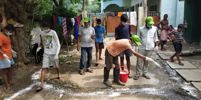
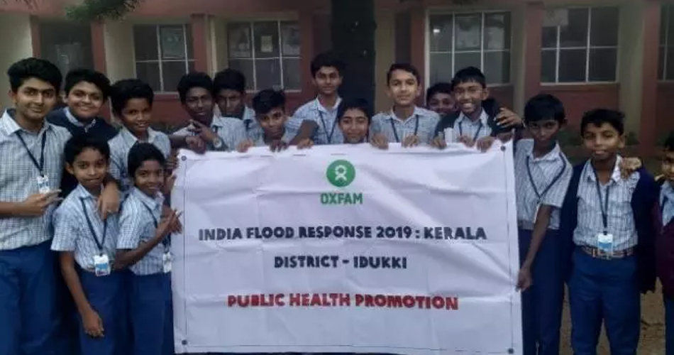
Oxfam India’s Response
Oxfam India distributed dry food ration to nearly 150 most vulnerable families in Noolpuzha GP of the Wayanad district during Kerala floods 2019. 200 sanitary napkins and 2500 soaps were distributed amongst women and young girls to ensure their menstrual hygiene. Nine awareness sessions on menstrual hygiene management were conducted by Oxfam India during Kerala floods 2019 for more than 350 women and 45 girls at the school and community level in order to educate them about the importance of healthy and hygienic living.
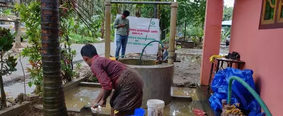
118 open wells were dewatered and chlorinated, benefitting over 1300 people in nearly 260 households. Awareness sessions on WASH practices were conducted in six schools, reaching out to nearly 600 children, to sensitise them on the importance of healthy living. Oxfam India organised village cleaning drives in more than 3700 households during Kerala floods 2019 as a preventive measure against spreading of diseases.
Click here to read more: https://www.oxfamindia.org/programdetails/1/humanitarian-response-and-drr
We need your support!
Support Oxfam India to help us reach out to more and more people in times of crises. Donate to Kerala Floods Relief Fund and help Oxfam India sustain its efforts of rehabilitating flood-affected people.
Maharashtra Floods
The major cause of flooding in Maharashtra is heavy rainfall that continues for a long period of time. While Maharashtra is not as prone to flooding as Assam, Bihar, and Kerala, it has experienced events of destructive floods in the past. In 2005, Mumbai received a record high rainfall of 84 centimetres (37 inches). This is the most rain a metro city with a population of over 10 million has experienced in a single day.[19]
The monsoon season in India brings with it moist, warm air from the Indian Ocean to coastal cities including Mumbai every year. The 2005 Mumbai Floods occurred exactly after a month of the 2005 Gujarat Floods. Floods in Mumbai lashed the metropolis on 26 July 2005, the day that brought the ever happening city of Mumbai to a standstill.
Maharashtra Floods 2019
The 2019 Maharashtra Floods affected more than 7 lakh people. More than 200 casualties were reported and over 1, 00,000 hectare agricultural land was severely damaged. Over 2 lakh households faced a severe shortage of electricity and water supply systems in approximately 400 villages was partially disrupted. Out of the many areas that were gravely impacted, Kolhapur and Sangli districts of Mumbai were hit the hardest, affecting more than 750 villages in 68 talukas of the two districts.
While heavy rainfall is a major reason behind Maharashtra floods, questions are also being raised about improper and ineffective flood management system in the state. Natural disasters like these are aggravated by water release from overflowing dams. Three of the biggest dams in Koyna, Radhanagari, and Warna regions of Maharashtra were already 100% full by the time floods hit the region. South Asia Network on Dams, Rivers and People (SANDRP) conducted a study of the Krishna River Basin to understand the root cause of the floods in 2019. The assessment showed mismanagement on releasing water from various dams, worsening the situation in Kolhapur, Sangli and Satara districts of Maharashtra.[20]
Oxfam India’s Response
Oxfam India conducted cleaning drives through eight villages of Sangli district, benefitting more than 5400 people. Hygiene kits were distributed in over 160 households in the Panchsheel Nagar Village of the Bhiwadi Gram Panchayat, Poluc Block, Sangli District. Three water supply systems were restored in Kohlapur and Sangli district of Maharashtra. This ensured access to safe drinking water for more than 22,000 flood-affected people.
Click here to read more: https://www.oxfamindia.org/programdetails/1/humanitarian-response-and-drr
We need your support!
Support Oxfam India to help us reach out to more and more people in times of crises. Donate to Maharashtra Relief Fund and help Oxfam India sustain its efforts of rehabilitating flood-affected people.
[9] walkthroughindia.com/walkthroughs/15-worst-ever-floods-in-india-over-last-decade/
[10] https://www.livemint.com/Politics/JEGERRSFHOVCAm86Pd1tnL/Why-Assam-faces-floods-every-year.html
[12] https://www.youthkiawaaz.com/2019/07/why-are-the-assam-floods-not-a-national-problem-for-india/
[17] https://www.independent.co.uk/news/world/asia/kerala-floods-latest-india-cause-flash-flooding-landslides-explained-a8500801.html